
COMO EL AGUA - accesibility plan for Vejer de la Frontera/ Cadiz / Spain
Vejer de la Frontera is one of the most picturesque white villages in the Andalusian Sierra. Additionally to its viewpoint character and its clearly visible origins as a fortress on the top of a steep hill, there is another characteristic feature.
The village has three valleys reaching up into the historical centre in which the surrounding landscape mix with the urban structure as they reach the top of the hill. They are a natural entrance of the surrounding landscape into the old fortress. Logically these served as main access routes, each one with a different character. In our proposal we maintain this difference, making it the base for a new accessibility concept.
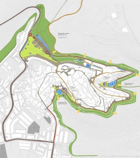
North Valley
-
Main access to the village, connection to A-48, main entrance of motorised traffic
-
BUS-transport hub and parking facilities with interchange from car to pedestrian
-
Representation and meeting place, park, multipurpose space
-
Ability to use the car park as new infrastructure for exhibitions, cultural events and local festivities
East Valley
-
Connection with the Barbate river and the marshes. New interpretation centre of the marshes and museum
-
Connection with tourist routes and entrance for soft mobility
-
Access to Plaza de España and new parking-facilities for residents
South Valley:
-
Access to the historical centre from the new part of the village
-
Leisure facilities, swimming pools, new meeting points for the village population
-
Expansion of the parking facilities and a new connection to the ring road
Distribution of traffic
The proposal is based on a double ring concept for different modes of transport.
The motorised traffic arriving in Vejer is filtered in the entrance hub in the north valley. Buses and non-residents may continue on
the main exit road or leave the car on one of the over 300 parking spaces. They will not have the possibility to enter the centre of the historical village.
Residents will be re directed to the one-way ring road from where they can access their residential zones. For this purpose a new road connects the main entrance to the existing ring road and we have established exit roads out of the centre and the village. For these roads we propose three different levels of speed limits: Main road 30 km/h; Ring-road: 20 km/h; Inner centre including exit roads: 7Km/h with pedestrian priority

A ring with different functions
This restriction policy combined with the one-way-distributor-ring-road concept for residents is the base to achieve the main goal of
keeping the motorised traffic out of the historic centre. The ring road will be equipped with adequate walkways inviting for a stroll around the centre to enjoy the views on the surrounding
landscape. The construction work of a new green belt can be used to locate a new drainage system to capture and store rainwater for irrigation of the green zones, separating used-water and rain
water-management.
On the outside of the retaining walls of the village we establish a second level of walkways and bike-paths linked to leisure uses.
This offers space to develop recreational areas with fitness equipment, picnic sites, climbing facilities in the perimeter wall and bike routes around Vejer.
Pedestrian access
A new pedestrian zone on the city balcony next to the entrance, which served as one of the main entrances for motorised traffic in
former times, serves as a starting point invites for a stroll through the narrow village.
Possible Walking routes between the entrance in the north and the new linear parking in the southeast generates a kind of "comb" of
pedestrian routes trough the inner centre with very little interference from cars, liberating the city life and orienting the whole village more in the direction of its landscape.
On the other hand we propose access points from the landscape oriented green belt into the inner centre.
The so called green points serve as vertical communication between different levels of the ring and as pedestrian access between the
landscape and the historical centre. These points are easily accessible which makes them ideal places to offer added functionality like bus stops for the circular bus, well designed rubbish
collection facilities and access points to the rain water reserve for irrigation. To make them clearly visible and recognisable from the inside they would be marked by green zones reaching from the
green belt into the city centre.


Competition entry in cooperation with Rubén
Alonso Mallén